Caldecott (Rutland)
Caldecott

| Pays | |
|---|---|
| Nation constitutive | |
| Région | |
| Zone | |
| Superficie |
4,71 km2 |
| Coordonnées |
52° 32′ 24″ N, 0° 43′ 12″ O |
| Population |
267 hab. () |
|---|---|
| Densité |
56,7 hab./km2 () |
| Statut |
|---|
| Code postal |
LE15 |
|---|---|
| Indicatif téléphonique |
01536 |
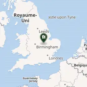
Caldecott est un village et une paroisse civile du Rutland, en Angleterre.
Histoire
Géographie
Notes et références
Liens externes
- Ressource relative à la géographie :
 Portail de l’Angleterre