How End
How End

The Chequers, près de How End
| Pays | |
|---|---|
| Nation constitutive | |
| Région | |
| Comté cérémonial | |
| Zone | |
| Coordonnées |
52° 03′ 32″ N, 0° 29′ 32″ O |
| Statut |
|---|
| Code postal |
MK45 |
|---|---|
| Indicatif téléphonique |
01234 |
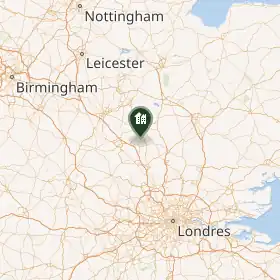
How End est un hameau anglais du Central Bedfordshire[1].
Notes et références
- ↑ (en) « How End, Central Bedfordshire », sur britishplacenames.uk (consulté le )
Liens externes
 Portail de l’Angleterre