Talakag
Talakag

| Nom officiel |
(en) Municipality of Talakag |
|---|
| Pays | |
|---|---|
| Région | |
| Province | |
| Superficie |
786,4 km2 |
| Altitude |
409 m |
| Coordonnées |
8° 13′ 55″ N, 124° 36′ 09″ E |
| Population |
77 027 hab. () |
|---|---|
| Densité |
97,9 hab./km2 () |
| Statut | |
|---|---|
| Dépenses |
352,1 M₱ () |
| Revenu fiscal |
510,7 M₱ () |
| Fondation |
|---|
| Code postal |
8708 |
|---|---|
| Indicatif téléphonique |
88 |
| Site web |
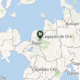
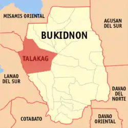
Talakag est une municipalité des Philippines située dans l'ouest de la province de Bukidnon, sur l'île de Mindanao.
SUbdivisions
Talakag est divisée en 29 barangays :
- Basak
- Baylanan
- Cacaon
- Colawingon
- Cosina
- Dagumbaan
- Dagundalahon
- Dominorog
- Lapok
- Indulang
- Lantud
- Liguron
- Lingi-on
- Lirongan
- Santo Niño (Lumbayawa)
- Miarayon
- Barangay 1 (Pob.)
- Barangay 2 (Pob.)
- Barangay 3 (Pob.)
- Barangay 4 (Pob.)
- Barangay 5 (Pob.)
- Sagaran
- Salucot
- San Antonio
- San Isidro
- San Miguel
- San Rafael
- Tagbak
- Tikalaan
Notes et références
 Portail des Philippines