Wheatland (Indiana)
Wheatland
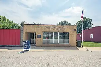
La poste de Wheatland.
| Pays | |
|---|---|
| État | |
| Comté | |
| Superficie |
1,06 km2 () |
| Surface en eau |
0 % |
| Altitude |
154 m |
| Coordonnées |
38° 39′ 51″ N, 87° 18′ 28″ O |

| Population |
390 hab. () |
|---|---|
| Densité |
367,9 hab./km2 () |
| Statut |
|---|
| Code postal |
47597 |
|---|---|
| Code FIPS |
18-83564 |
| GNIS | |
| Indicatif téléphonique |
812 |
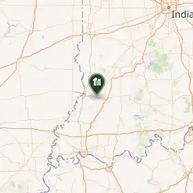
Wheatland est une municipalité américaine située dans le comté de Knox en Indiana.
Lors du recensement de 2010, sa population est de 480 habitants[1]. La municipalité s'étend sur 0,41 mille carré (1,06 km2)[1].
Wheatland est fondée en [2],[3],[4]. Le bureau de poste local — appelé Berryville depuis 1830 et géré par la famille Berry — adopte alors le même nom[2]. Wheatland est nommée en référence à ses champs de blé (en anglais : wheat)[3],[4]. Elle devient le centre agricole de cette région minière[4].
Notes et références
- 1 2 (en) Bureau du recensement des États-Unis, « Population, Housing Units, Area, and Density: 2010 - State -- Place and (in selected states) County Subdivision 2010 Census Summary File 1 », sur factfinder.census.gov (consulté le ).
- 1 2 (en) Ronald L. Baker, From Needmore to Prosperity: Hoosier Place Names in Folklore and History, Indiana University Press, (lire en ligne), p. 345.
- 1 2 (en) History of Knox and Daviess Counties, Indiana, The Goodspeed Publishing Co., (lire en ligne), p. 270.
- 1 2 3 (en) Jess Cohen, « Schools live on in memories of Wheatland 'Jeeps' », sur suncommercial.com, (consulté le ).
Voir aussi
 Portail de l’Indiana