Xian autonome li de Changjiang
| Chāngjiāng lízú Zìzhìxiàn 昌江黎族自治县 | |
.png) Localisation du xian de Changjiang (en rose) dans la zone administrée directement par la province (en jaune) | |
| Administration | |
|---|---|
| Pays | |
| Province ou région autonome | Hainan |
| Préfecture | administration directe |
| Statut administratif | Xian autonome |
| Code postal | 572700[1] |
| Indicatif | +86 (0)+86 (0)898 |
| Immatriculation | 琼D |
| Démographie | |
| Population | 225 131 hab. (1999) |
| Densité | 139 hab./km2 |
| Géographie | |
| Coordonnées | 19° 21′ 58″ nord, 109° 02′ 32″ est |
| Superficie | 162 051 ha = 1 620,51 km2 |
| Localisation | |
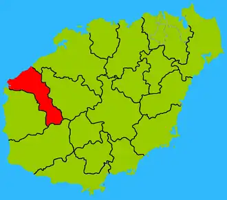 Localisation dans la préfecture de administration directe. | |
| Liens | |
| Site web | changjiang.hainan.gov.cn |
Le xian autonome li de Changjiang (昌江黎族自治县 ; pinyin : Chāngjiāng lízú Zìzhìxiàn) est un district administratif de la province chinoise insulaire de Hainan. Il est administré directement par la province.
Démographie
La population du district était de 225 131 habitants en 1999[2].
Centrale Nucléaire
Une centrale nucléaire y est en construction depuis 2008.
Notes et références
- ↑ (en) Codes postaux et téléphoniques de Hainan, (en) China Zip Code/ Telephone Code, ChinaTravel.
- ↑ (en) National Population Statistics Materials by County and City - 1999 Period, in « China County & City Population 1999 », sur Harvard China Historical GIS (version du sur Internet Archive)
Voir aussi
Lien externe
- (zh) Site gouvernemental
 Portail de la Chine